

Tracing the Aceh Earthquake and Java’s Fault Lines
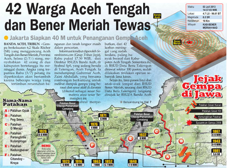
The newspaper spread from Tribun, as presented in infographic, reports on a devastating 6.2 Richter Scale (SR) earthquake that struck Central Aceh and Bener Meriah on Tuesday, July 2, 2013. Under the bold headline “42 Warga Aceh Tengah dan Bener Meriah Tewas” (42 Citizens of Central Aceh and Bener Meriah Killed), the report details the tragic loss of life, ongoing search efforts for residents buried under collapsed buildings or landslides, and a response budget of IDR 40 billion mobilized by Jakarta for disaster relief. The publication pairs this breaking news with a technical data block tracking the exact parameters of the Aceh tremor—including its coordinates, a depth of 10 km, and a visual 3D epicentral ripple diagram over the northern tip of Sumatra.
While the main text details the localized crisis in Sumatra, the expansive map layout at the bottom, titled “Jejak Gempa di Jawa” (Traces of Earthquakes in Java), cross-references this disaster with historical geological vulnerabilities across Java island. This comprehensive infographic charts major fault lines (such as Patahan Opak, Patahan Kedungbener, and Patahan Besar Cilacap-Pamanukan-Lematang) using color-coded directional markers to explain left-lateral and right-lateral strike-slip faults (Patahan Geser Kiri and Patahan Geser Kanan). By plotting historic seismic events and Modified Mercalli Intensity (MMI) ratings dating back to 1840—alongside a prominent star marking the 2006 Yogyakarta epicenter—the infographic informs readers of the continuous, systemic tectonic shifts beneath their feet.